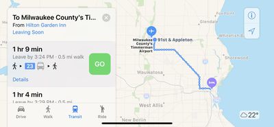
Apple recently updated its Maps app to add transit directions and data for Milwaukee, Wisconsin and Omaha, Nebraska, two places where transit information was not previously available outside of Amtrak routes.
Apple Maps users in Milwaukee and Omaha can now select public transportation routes when getting directions between two locations, with bus lines available in both areas.

Apple has not yet added Milwaukee or Omaha to the website where it lists areas transit directions are available, but it's likely these two locations will be listed soon.
Transit directions were first added to Apple Maps in 2015 with the launch of iOS 9. Maps initially only offered transit information in a handful of cities, but over the course of the last three years, Apple has worked to expand the feature to additional areas.
Transit information is now live in dozens of cities and countries around the world, with a full list available on Apple's iOS 11 Feature Availability website.
(Thanks, Geoffrey!)


Top Rated Comments
I am so gut wrenchingly amazed that I just want Apple to slow down and catch a breath before I am completely overwhelmed with rapidly expanding capabilities!
At this rate Google Maps is in real trouble for sure. Doomed.
Maybe Apple should sack half the Apple Maps team to give Google a breather. How about the old dude with emphysema that doesn’t like to travel anymore, and just retain the young hipster on his own, you know the one that does the coding and doesn’t get out much. A fifty percent saving on wages would help Mr Cook’s margins no end.