Apple's Maps app rebuild continues apace this week, with the company following its pattern of rolling out the enhanced maps in adjacent continental U.S. states.
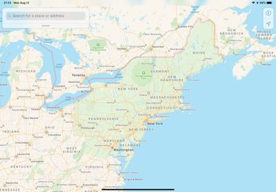
Last week we reported that revamped Maps had become available across Texas, Louisiana, and the southern half of Mississippi.
Now the rollout is creeping up the northeast United States, taking in the likes of Washington D.C., Maryland, Pennsylvania, New York, Massachusetts, and Maine.
You can spot the updated regions by looking for more landscape details like sports fields, parking lots, ground cover, foliage, pools, pedestrian pathways and the like.
The data is gathered by Apple's own fleet of sensor- and camera-equipped vehicles, as well as first-party data gathered from iPhones using Apple's differential privacy. The combined data is also being made to ensure search results are more relevant.
The improvements initially rolled out in Northern California in July 2018, followed by Hawaii and Southern California in November 2018, and Arizona, New Mexico, and the Las Vegas metropolitan area in April 2019.
At WWDC 2019, Apple said the updated maps will roll out to the entire United States by the end of the year, followed by additional countries in 2020.
(Thanks, Erik!)













Top Rated Comments
https://appleinsider.com/articles/16/07/07/why-apples-transit-maps-are-rolling-out-so-slowly
[doublepost=1565700697][/doublepost]No, Apple has already done the UK, so you should be good to go in 2020.
Define "most of the world". Apple has taken the approach to work with local transit companies to get the exact data. There have been many recent articles written on the integration of actual bus and train positions within Apple Maps that you will not see as much in Google or other transit apps. The spread of updated transit info across Europe in particular has been frequent over the past 2 months.
And with this comment, we have all the standard "I guess I won't see it until 'insert far off date' in my 'insert country'" comments out of the way.
Apple spent almost 5 years working on the program for their mapping...not the actual mapping. You can see from the data right in the new areas that it was collected within the past year. Knowing this and that Apple cars have been in the UK as early as late 2018, it would make more sense to assume that the UK will show up as early as the first half of 2020.
From Apple’s website:
https://mwp14.ls.apple.com/imagecollection/
Go to San Francisco (and other parts of California) on Apple Maps right now on any device running iOS 13 / iPad OS and you can see how good Look Around is. It’s really impressive.
* Phone data - Every iPhone ships with the ability to track phone movement for traffic data unless turned off by the user. It's not the easiest thing to find, so almost all iPhones track movement. Yes, anonymously, but sending traffic data nonetheless.
* Traffic authorities - Where available (most major cities) Apple, like Google, gets traffic from transportation agencies including lane/road closures so they may be integrated into the map.
* Traffic history - This is a Google exclusive (sort of like their graphs showing when businesses are "busy"). They use an algorithm that predicts traffic based on past history. This is why Google has chosen to go the route of the "green/yellow/red" on their map. It is expected that Apple is heading down this route as well since they will own the data in the new areas, but has yet to have been confirmed (the prediction of traffic, not adding green to "no traffic" areas)
I've copied the articles so many times, I'm sick of it. Just do a web search. Apple has been shown to give the same or more accurate ETA's than Google or Waze.
At the end of the day, most people will choose their app based on GUI and integration with other apps or specific data they may provide that other apps don't (police alerts, bicycle routes, etc.). I HATE the way Waze looks/works, but when I was commuting, I used it religiously since I like to drive way over the speed limit. Three years ago, I used Apple maps for routing, but always double-checked POI's with Google since the data simply wasn't there yet with Apple. I've used Apple Maps only for the past 2 years without major issues with Google and Waze running in the background (I travel a LOT) just to test them in different areas of the United States. In my experience, whether it is a 15 minute drive or a 12 hour drive, Apple has always had a more accurate ETA from the start than Google or Waze (I gave up on HERE when I stopped traveling to Europe).
I am definitely more of an Apple defender than most, but living in the USA helps with that as well as the fact that my preference for the Maps UI blows away Google and Waze...my opinion. I like the way it looks, shows the data, I love CarPlay, etc. It's good to have choices.
[doublepost=1565703693][/doublepost]Check the AppleMaps thread on Reddit. There has been a post nearly every week with updates across Italy, Germany, France, Austria?
[doublepost=1565703771][/doublepost]You're correct...I should just take your "so far behind" opinion as gospel. noted.