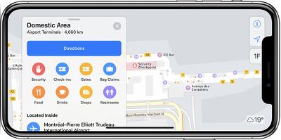
Apple Maps has gained indoor maps for an additional four international airports and one shopping mall around the world.

The recently enabled airports include Charlotte Douglas International in North Carolina, Montréal–Pierre Elliott Trudeau International and Québec City Jean Lesage International in Canada, and Taoyuan International in Taiwan.
When searching for those airports, Apple Maps users can tap "look inside" or simply zoom in to view terminals, boarding gates, security checkpoints, airline check-in desks, baggage claim carousels, information kiosks, restrooms, stores, restaurants, parking garages, and even escalators, elevators, and stairs.
An indoor map is also now available at the Trinity Leeds shopping center in England, according to Apple's iOS feature availability page.
Indoor maps at shopping malls make it easier to find the exact location of stores, restaurants, restrooms, escalators, elevators, and stairs on each floor. The feature enables users to filter stores by categories, such as clothes, shoes, accessories, beauty, food, and drinks, with detailed place cards for each.
When the feature launched with iOS 11, indoor maps were only available in a handful of airports and shopping malls around the world, but Apple has been steadily adding locations over the past year.
The list includes airports and shopping malls in select cities across North America and Europe, including Baltimore, Berlin, Boston, Chicago, Dallas, Houston, London, Los Angeles, New York, Philadelphia, Portland, San Jose, San Francisco, Seattle, Toronto, and Washington, DC. The full list can be viewed here.


Top Rated Comments
(Edit: Just poking at the image. An actual iPhone X will display the content properly)
Your words could be valid but they are not.
While you claim that the world is as it is, Google is also an American company.
And Google has, without overstating, 1000x more rich data than Apple in Poland.
Is the world smaller for Google?
Is Google NOT an American company?
Is Google capable of magic?
If Apple wants to stay in game, they need to invest, but adding Google Maps to the CarPlay seems like an admission of failure.
Apple Maps is a base for many apps, if they neglect them even more outside the America, they won't matter since people in Europe will continue to use Google Maps as a backend for their apps.
Then why bother releasing products internationally if they won’t have full support? I’m stuck in a situation right now that Apple Maps sucks, Auckland houses 1/4th of our population and despite that the mapping data they have is ****. On top of that iOS doesn’t allow you to set default apps so I can’t even use Siri with Google Maps. I’m literally getting punished for living in a different country. Whereas with Google Maps there are no such issues and everything works fine.
It’s a whole lot easier for you to spout that nonsense when you’re not directly affected by it and are missing a lot of features. Have some empathy.
[doublepost=1528446764][/doublepost]Google Maps data is actually much better where I live, just because you’ve had the opposite experience does NOT make any complaint less valid.
Can we all stop pretending that the world is really small already. As much as I hate to say Google is an American company and will focus on American users first. From there I don’t think New Zealand (if that’s what NZ stands for) is a big fish for Google. For instance I looked at population statistics and New Zealand has .02 the population of US. That’s small fish. China, UK, Spain, etc are bigger targets. But again you’ll prolly see American cities most of the time since the population is big, US is huge, and It’s Googles home turf.
Apple "rents" their base map data from TomTom, have for years. Don't listen to me - compare Apple Maps basemap data to TomTom's here ('https://mydrive.tomtom.com/en_us/#mode=viewport+viewport=46.17856,-123.41388,13.7,0,-0+ver=3') to my attached screen shot...
No other mapping data source on Earth has the same typo error - Pugget Island doesn't exist, Puget Island does. I work in this industry, I've got others, in other countries that I do business in. There are businesses that produce dairy and mechanical products on that Island, my clients have griped that people can't find them because of that typo. Two roads have been closed in that area due to ecological disasters, but TomTom still shows them as viable options even though I've informed them several times via official channels over 4 years (backed by the Corps of Engineers as well); I had to hire a Dutch translator to get one of those errors addressed.
Those errors in Nova Scotia that AI reported on a few weeks ago ('http://appleinsider.com/articles/18/05/24/apple-maps-mislabeling-locations-in-rural-canada'), also due to base map errors from TeleAtlas. Another screen shot from TomTom's Drive portal:
My gripe with Apple is that they rent data from TomTom's TeleAtlas, a company that I've worked with for years. They. Don't. Care. Send. Me. A. Check. Then. We'll. Talk. Maybe. is their mantra.
Gripe at Apple for pushing TomTom to get their data straight and/or swap out for MapBox or HERE base maps. Gripe at TomTom to get their data right. I'd offer that MR's members focus their angst constructively. My business pays several thousands of $$$ every year to "rent" GIS data for base map usage, TomTom's data is always pretty much useless, year in, year out.</rant> FWIW, Google's data isn't much better...
Author probably took screenshot on his iPhone X and put that inside iPhone X marketing frames which resulted in this overlap.