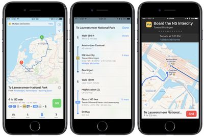
Apple Maps has been recently updated with public transit information for those living in and traveling to the Netherlands. Transit directions allow users to navigate the Netherlands thanks to integration with the Intercity direct train line, various bus routes, trams, and ferries.

Transit in the Netherlands includes up-to-date advisory information with the help of data accumulated from various local transportation companies including NS, Connexxion, and GVB (via iPhoned). With the data, Apple Maps can warn users about reduced service, or a complete service shutdown, and update their transit trip directions accordingly.
Apple first added in a small amount of transit data to various Dutch cities last week, including the appearance of train, tram, and metro stations for a few areas, but had yet to turn on live schedule information for public transport. Most recently, areas including Singapore and Adelaide, Australia have received transit updates in Apple Maps.
Transit directions first launched with iOS 9 back in 2015 with just a handful of cities supported, but now Apple has kept up a consistent pace with adding new areas all over the world. In total, more than 10 countries now include transit directions, as do most major United States cities like Boston, Chicago, New York, and Los Angeles. It appears the rollout in the Netherlands will be ongoing since the area has yet to appear on the supported transit list on Apple's website.


Top Rated Comments
It works very well I think. Would be nice to be able to see at what platform trains stop, but overall it's very good. Now I can actually ditch the third-party 9292 app that is commonly used in my country for transit information. It's a good app, but the fact that Transit in Apple Maps seems to work so well AND that it is integrated with Siri as well is great. Works on my iPhone, Mac and even my Apple Watch. Will definitely be using it to its full extent. :)
Good job Apple! Now you just need to bring Apple Pay, Apple News, QuickType suggestions, TV Shows etcetera to The Netherlands. It's progress though. :P
This article explains very well the different approaches, and why Apple Maps approach is superior. Having used both, I am glad Apple didn't simply mimic Google.
http://appleinsider.com/articles/16/07/07/why-apples-transit-maps-are-rolling-out-so-slowly
When Google maps transit was in iOS5 it converted every country and major city!