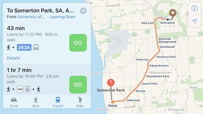
Apple Maps has been updated with comprehensive transit data in Adelaide, Australia, enabling iPhone users in the city to navigate with public transportation, primarily including Adelaide Metro buses and commuter trains.

Apple Maps gained a Transit tab in iOS 9. The feature lags several years behind Google Maps, but Apple's public transportation support is exhaustive, mapping all station entrances and listing departure times.
At launch, the feature was limited to Baltimore, Berlin, Boston, Chicago, London, Los Angeles, Mexico City, New York, Philadelphia, San Francisco, Sydney, Toronto, and over 300 cities in China. Since then, Apple has been working to expand support for public transportation to other cities around the world.
Newer additions include Atlanta, Columbus, Dallas, Denver, Detroit, Honolulu, Houston, Kansas City, Manchester, Melbourne, Miami, Minneapolis–Saint Paul, Montréal, New Orleans, Paris, Portland, Pittsburgh, Prague, Rio de Janeiro, Sacramento, Salt Lake City, San Antonio, San Diego, Seattle, and Vancouver, B.C.
A complete list of cities that support Transit in Apple Maps is available on the iOS Feature Availability page of Apple's website.
(Thanks, Bernd!)


Top Rated Comments
Often the POIs in Google Maps and Bing Maps cannot be found in Apple Maps. That's just useless.
If you enter the game, be a man and beef up, burn some money to catch up. That's how business work. If you keep lagging behind don't blame people for telling you're in a tail of this race.
I was first suspicious when the arrive time was different by four minutes, but still used Apple Maps. I should have known better, as Apple Maps placed me a few blocks away from where I needed to go. I quickly had my wife open up Waze, and it brought me exactly where I needed to be.