Apple Maps Expands Transit Data to Columbus and Pittsburgh - MacRumors
Skip to Content

Apple Maps Expands Transit Data to Columbus and Pittsburgh

by

Apple Maps has been updated with comprehensive transit data for the U.S. cities of Columbus, Ohio and Pittsburgh, Pennsylvania, enabling iPhone users in the areas to navigate using public transportation, including buses or light rail.

apple-maps-transit-columbus-pittsburgh
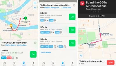
Transit routing options in the Pittsburgh metropolitan area include Port Authority of Allegheny County buses and light rail, while directions for Central Ohio Transit Authority buses are provided in the Columbus metropolitan area.

Apple introduced Transit in Maps as part of iOS 9 in select cities around the world, including Baltimore, Berlin, Boston, Chicago, London, Los Angeles, Mexico City, New York, Philadelphia, San Francisco, Sydney, Toronto, and over 300 cities in China. The feature has its own tab in Apple Maps on iOS 10 when entering directions.

The feature has since expanded to a number of regions around the world, including Atlanta, Dallas-Fort Worth, Denver, Honolulu, Kansas City, Miami, Montréal, Portland, Prague, Rio de Janeiro, Sacramento, San Antonio, San Diego, Seattle, parts of New South Wales in Australia, and parts of British Columbia in Canada.

(Thanks, Ram!)

Top Rated Comments

127 months ago
I know competition is good and all, but I kind of wish Apple would give it up already and allow users to select Google Maps as the default map program.
Are you kidding? Apple will be launching its new base map in 2017 and already iPhone users are using it 5 BILLION times a week even though they can easily use Google or other map apps.
Score: 4 Votes (Like | Disagree)
desmond2046 Avatar
127 months ago
Oh I didn't even know Columbus has public transportation...
Score: 2 Votes (Like | Disagree)
Fzang Avatar
127 months ago
Meanwhile, millions and millions of overworked, stressed and tired commuters have to make do with following the analog signs pointing to exit C, and manually figuring out whether their city has a tram or a light rail.
Score: 2 Votes (Like | Disagree)
Keane16 Avatar
127 months ago
I know competition is good and all, but I kind of wish Apple would give it up already and allow users to select Google Maps as the default map program.
You already mention it, but choice is good.

More importantly, Google does things I don't want to be involved with if possible. At the time of the change from Google maps to Apple Maps:

- Apple wanted turn-by-turn and vector map tiles, Google was holding these back as advantages for the Android platform.
- In return for providing the features Apple (and iOS users) asked for, Google wanted more control over the Maps app, more branding, and more identifiable location data. Apple wouldn't budge.

I'm glad Apple went down this path - privacy is important. It would've been easy to give Google access to iOS user data in return for the features.

It might not have worked out the way they wanted to, but we now have a great Google maps app (with vector map tiles and turn-by-turn). And For those that want it privacy via Apple Maps (and in certain countries like mine - zeros issues maps wise. However points of interest, while improving, are still lacking).

On the point of setting default apps - that's a whole different argument, and a decision that probably won't be changing soon.
Score: 1 Votes (Like | Disagree)
ksnell Avatar
127 months ago
COTA: To get home would take 2 hours 45 min.
Driving: 19 minutes.

Why public transit just doesnt work for sprawling metros like Columbus.
More like why public transit doesn't work for America.
Score: 1 Votes (Like | Disagree)
127 months ago
No, I'm not kidding. I've been using google maps for who knows how long and have a preference for its UI.

What's a base map? Is Apple set to revamp their map app next year?
The Apple maps app will be revamping in about an half-hour.
Score: 1 Votes (Like | Disagree)

Popular Stories

Apple Maps General

Apple Maps Flyover Gets a Visual Upgrade in iOS 27

Monday June 8, 2026 4:29 pm PDT by
Apple Maps is getting a visual update in iOS 27, with Apple planning to introduce new aerial imagery that's combined with Visual Intelligence models. Apple said everything will have sharper detail, from the "shapes of individual trees to the way light reflects off the glass of skyscrapers." Flyover is an Apple Maps view that lets users see more than 350 cities in 3D with detailed...
Apple Says iOS 27 Adds These 12 New Features to Your iPhone Feature

Apple Says iOS 27 Adds These 12 New Features to Your iPhone

Tuesday June 9, 2026 9:47 am PDT by
iOS 27's key new feature is a more intelligent and personal version of Siri, but the changes go well beyond that. In a press release today, Apple outlined additional enhancements coming across Apple Maps, Find My, Apple Wallet, Apple Music, and more. Apple Maps has gained an enhanced Flyover experience powered by AI, enabling you to view aerial imagery in "stunning detail" for select cities. ...
liquid glass app icon

Apple Maps to Get These 10 New Features in iOS 27

Thursday June 11, 2026 5:45 am PDT by
Apple Maps is getting a range of new features in iOS 27, headlined by an upgraded Flyover experience that uses AI to improve the realism and detail of its aerial imagery. Flyover is a longstanding feature of Apple Maps and lets users explore more than 350 cities in 3D with detailed landmarks, roads, parks, and buildings. Apple described the enhanced Flyover in iOS 27 as combining aerial...