Apple today updated its Maps app to add Transit information in Seattle, allowing iOS users living in the city to incorporate public transportation options like the Link Light Rail, Monorail, buses, and more into Maps when seeking directions.
Transit directions within Maps became available with the launch of iOS 9, and while Apple offered directions in a limited number of cities to begin with, the availability of Transit directions has since expanded to encompass 16 cities around the world along with dozens of cities in China.
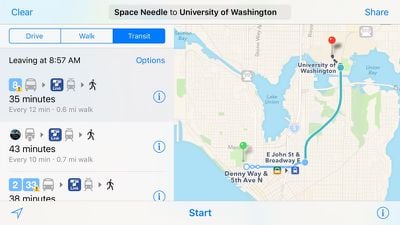
Apple's iOS 9 Feature Availability page has not yet been updated with the addition of Seattle, but the information should be added in the near future. Including Seattle, Transit directions are now available in Austin, Texas; Baltimore, Maryland; Berlin, Germany; Boston, Massachusetts; Chicago, Illinois; London, England; Los Angeles, California; Mexico City, Mexico; Montreal and Toronto, Canada; New York City, New York; Philadelphia Pennsylvania; San Francisco, California, Sydney Australia; and Washington, DC.
Though also unlisted on the Feature Availability page, Transit directions were also added for Portland, Oregon last Monday.
















Top Rated Comments
But seriously, once Apple starts rolling out more than one city a week, MacRumors will group several cities into one post. Just as they do with Flyover cities.
[doublepost=1461004466][/doublepost]They have recently gone from one city every few months to one city a week. That suggests they are getting better at integrating the data. It won't progress fast enough to satisfy everyone, but it appears they are accelerating.
[doublepost=1461025093][/doublepost]This is super exciting! AM is a lot more aesthetically pleasing than GMaps and I think the UI is a little better, so it's great to finally have an alternative.
GMaps and Apple Maps are almost certainly using the same resources from King County/OneBusAway for bus routes, schedules, stops and realtime arrival. In my experience, there are certainly issues, but not enough to possibly make me go back to learning and researching timetables. 99% good. Apple Maps is prettier. It'll probably be as buggy.