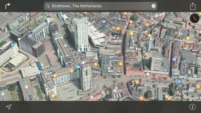
Apple today added 20 new Flyover locations to Apple Maps on Mac and iOS, highlighting landmarks and features across several countries including France, Italy, Japan, Australia, Switzerland, Austria, Germany, the UK, South Africa, and the United States.
For those unfamiliar with the Flyover feature in Apple Maps, it lets users see photo-realistic 3D videos of select locations, with tools for zooming, panning, and rotating to get a closer look at notable landmarks and points of interest. Some of the locations listed may have previously been available as Flyover destinations, but were just added to Apple's list of Flyover locations.

The full list of new Flyover locations is available below:
- Adelaide, Australia
- Amiens, France
- La Rochelle, France
- Nantes, France
- Toulouse, France
- Berne, Switzerland
- Bremen, Germany
- Columbus, Ohio
- Louisville, Kentucky
- South Bend, Indiana
- Springfield, Missouri
- Tucson, Arizona
- Dresden, Germany
- Eindhoven, Netherlands
- Johannesburg, South Africa
- Middlesbrough, UK
- Salzburg, Austria
- Taormina, Italy
- Toyoma, Japan
- Virgin Islands
Flyover was first introduced in 2012, but over the last four years, Apple has steadily added new Flyover locations to the Maps app. In 2015, Apple updated some major Flyover locations with real-time animated landmarks, making the Flyover experience even more immersive. Many Flyover locations have an additional City Tour feature that walks users through different landmarks in each city.
Along with new Flyover locations, the Maps app has been updated in Taiwan and Finland. In Taiwan, iOS users now have access to traffic information, and in Finland, the Nearby feature introduced in iOS 9 is now active, allowing users to get information on local businesses located near them.


Top Rated Comments
1) helicopter view
2) street view
Since I don't own a chopper yet I still need street view.
If I want to know my surroundings at a location, I always head to Street View. Fly over is limited to a handful of cities, unlike Street View.
Sure, I find flyover is fun ( a toy ), but not useful. I fly over some locations to kill time.
Apple came up with flyover because they couldn't do street view. It's a second lesser option.
Apple cannot replicate street view and I can generally live with that. But either decide fly over is valuable and spend some money to roll it out or quit it.
No, I don't think they did. Now we're getting a 3D satellite view which is vastly better than a flat one and suddenly an overhead view is useless. Weird.
Since Flyover arrived I use Street View about 5% as much as I used to. Its just way, way, way too slow. And I guess I'm not the only one, becuase Google are rolling out their own Flyover.