Apple today made several updates to its Maps app around the world, adding new Flyover locations, expanding Maps Traffic info, and bringing the Nearby feature in Maps to additional countries.
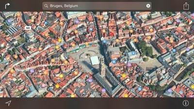
New Flyover locations available today include Aomori, Japan; Bruges, Belgium; Lake Powell, Utah; and Limoges, France. Some of the locations listed may have previously been available as Flyover destinations, but were just added to Apple's list of Flyover locations.
For those unfamiliar with the Flyover feature in Apple Maps, it lets users see photo-realistic 3D videos of select locations, with tools for zooming, panning, and rotating to get a closer look at notable landmarks and points of interest.
Along with new Flyover locations, Apple's website has been updated to note that traffic information is now available in the Maps app in Hong Kong and Mexico, bringing the total number of countries with traffic data available to 29.
Nearby, a feature introduced with iOS 9, has also been expanded to the Netherlands and the United Kingdom. Nearby brings up local points of interest in the Maps app, allowing users to quickly locate restaurants, gas stations, coffee shops, and more.
Finally, Los Angeles is now listed as an official location with transit directions available, joining Baltimore, Maryland; Berlin, Germany; Boston, Massachusetts; Chicago, Illinois; London, England; Mexico City, Mexico; New York City, New York; Philadelphia, Pennsylvania; San Francisco, California; Sydney, Australia; Toronto, Canada; Washington, DC; and China.
Transit information first became available in Los Angeles in December of 2015.
















Top Rated Comments
Flyover is completely useless against Street View, the later is so convenient when trying to know exactly where the place you are going is, and how it looks from the outside.
Seamless integration with Flyover, and three-dimensional free movement throughout a city, at street level and above, not restricted to teleporting between bubbles as per Google's Streetview.
There is a reason these cars have been spotted everywhere over the last year or so.
I disagree. I like and use both Street View and Flyover. But use them for different things.
When I'm in a new City, Flyover is great for getting a quick and dirty look around - more detailed than a flat map but way faster to navigate than Street View. It was great when I visited Rome 2 years ago - lots of winding alleys that look similar, Flyover helped a lot. Street View in this situation would be slow and annoying.
Street View is great when I have more time and want more detail. Pretty rare that I actually need it day to day but when I do it's really useful. When I bought my house I used it to check the surrounding streets.
I'm glad on iOS I have both.
When available, Flyover is like magic. I spend hours on it with my daughter.
Integrate the two technoligies and you'll get the next gen maps.
[doublepost=1453651948][/doublepost]OMG, I just checked Bakersfield, the place is amazing! Looks like Area 51 unfolded, so eerie.