Google Maps for iOS Updated With Spoken Traffic Alerts - MacRumors
Skip to Content

Google Maps for iOS Updated With Spoken Traffic Alerts

by

Google today updated its Google Maps app to version 4.12, adding spoken traffic alerts in navigation mode as well as the ability to easily add new or missing businesses from the app's sidebar.

googlemapsspoken
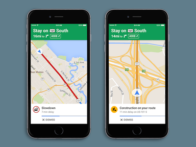
Spoken traffic alerts will tell users about traffic congestion and incidents on a user's route. Additionally, users will get traffic descriptions summarizing traffic conditions before they set off on their journey. The feature is similar to Google-owned Waze's notifications, which also verbally points out traffic congestion, incidents and the location of police in the area.

Google Maps is a universal app available for free in the App Store. [Direct Link]

Top Rated Comments

138 months ago
Great to see Google is catching up on this feature. Apple already had this earlier this year at the start of iOS 9 beta.

Attachment Image
Score: 9 Votes (Like | Disagree)
mejsric Avatar
138 months ago
If there is no Apple Map then iPhone users probably won't receive this update...

Thanks Apple for creating Apple Map.
Score: 8 Votes (Like | Disagree)
138 months ago
It’s such a shame that Google owns these two applications, they are simply the best in their class. Pity, I don’t want to have anything to do with Google.
Score: 7 Votes (Like | Disagree)
138 months ago
shame you are missing some of the best iOS apps due to what reason?
Google’s business model and attitude towards user privacy for a start. They are ruthless in their collection of data and I’m not going to hand over a steady supply of GPS data along with persistent identifiers for them to store forever and analyse. This data is too sensitive and Apple promises not to do this. Google Maps is a carrot and stick for what they are really after and for me it isn’t a relationship I want to have.
Score: 6 Votes (Like | Disagree)
Spink10 Avatar
138 months ago
If there is no Apple Map then iPhone users probably won't receive this update...

Thanks Apple for creating Apple Map.
Very good point
Score: 4 Votes (Like | Disagree)
shamino Avatar
138 months ago
You do realise that obeying the speed limits would even be more of lifesaver ;-)
Not necessarily. Many cities (well, at least Washington DC, which I'm personally familiar with) sets up countless photo speed traps. Like when they decide stick a 35MPH sign on an interstate highway in order to issue several thousand $100+ tickets a day to everybody who is (safely) driving 55-65 on that road.

Slamming on your brakes to obey that limit would be far more dangerous than going through at 55 and getting the ticket.

Of course, avoiding Washington DC altogether is an even bigger lifesaver, but that's not always an option.
Score: 3 Votes (Like | Disagree)

Popular Stories

Apple Event Logo

Apple to Release These 15 New Products Later This Year

Friday June 12, 2026 7:45 am PDT by
Apple's annual WWDC developers conference is drawing to a close, but there is still a lot to look forward to in the second half of the year. Apple is expected to release at least 15 more products later this year. Now that the more intelligent and personal version of Siri has finally arrived in beta, a full two years after Apple first previewed it at WWDC 2024, we should begin to see some new ...
Apple Lists 250 Changes Across iOS 27 and More Feature

Apple Shares List of 250 Changes Across iOS 27, macOS Golden Gate, and More

Wednesday June 10, 2026 1:34 pm PDT by
During its WWDC 2026 keynote on Monday, Apple briefly showed a slide with hundreds of new features and enhancements coming across iOS 27, macOS 27 Golden Gate, watchOS 27, tvOS 27, and visionOS 27. All of the software updates are currently available as developer betas, and they are expected to be released to all users in September. We already highlighted some of the key new features from the ...
liquid glass app icon

Apple Maps to Get These 10 New Features in iOS 27

Thursday June 11, 2026 5:45 am PDT by
Apple Maps is getting a range of new features in iOS 27, headlined by an upgraded Flyover experience that uses AI to improve the realism and detail of its aerial imagery. Flyover is a longstanding feature of Apple Maps and lets users explore more than 350 cities in 3D with detailed landmarks, roads, parks, and buildings. Apple described the enhanced Flyover in iOS 27 as combining aerial...