MacPrime.ch notes that Apple has recently added three new locations to their Maps Flyover feature found in iOS.
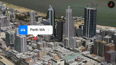
The new locations include Perth (Australia), Saint-Tropez (France) and Cordoba (Spain).
The 3D flyover features was introduced in iOS 6 and based on the technology of C3 Technologies which was acquired by Apple in 2011. Apple has been slowly expanding coverage since its launch and maintains a list of 3D-enabled locations on their website.











Top Rated Comments
Agreed. These 3D maps look like the sun melted everything in its path (read: terrible) at a close enough distance, so they're useless beyond a quick virtual tour of a city.
At this rate, the new buildings they're finishing up across the street won't show up in Apple Maps before the beginning of the 22nd century.
Interesting. My experience has been pretty much the opposite. I've only used Flyover to show someone who doesn't have an iOS device what Flyover is about. It's neat for about 10 seconds. If I could fly, Flyover would be much more useful.
From a practical usage standpoint, I much prefer Google Street View. GSV shows me what to expect as I'm driving or walking to a destination. That's what I want because that's how I get to where I'm going.
To top it off, I've already noticed GSV images getting updated two or three times in the last three or four years. They're doing a heck of a lot of driving around; and they are now going over areas they've already covered to update their imagery. Any way you slice it, that's impressive. I love Apple and Apple products in general; but in the mapping department, they're way behind Google, in my opinion.