Earlier this year, major GPS navigation firm Garmin released its first turn-by-turn navigation app for iOS. But rather than having all map data included within the application, Garmin StreetPilot relied on data access to download maps as needed. Garmin touted the decision as offering smaller and quicker downloads with the most up-to-date mapping data, but it also required users to tap into their data plan to use the application and could result in poor navigation in areas of poor or no cell coverage.
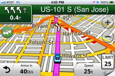
To address those issues, Garmin today announced the release of several "StreetPilot Onboard" apps offering full map data bundled within the apps to allow for offline navigation.
Garmin StreetPilot Onboard puts the vast preloaded database and intuitive interface of a Garmin nüvi into the iPhone you use everyday – without tapping into your dataplan. With ultra-fast map drawing, panning and zooming, the preloaded maps and Points of Interest offer peace of mind in knowing that wireless coverage and dataplan usage are not required to access maps or calculate routes. So just as with a nüvi, the maps and directions are always there when you need them most – especially when you can’t get cell or Wi-Fi signals or your dataplan is running low.
Three versions of StreetPilot Onboard are available:
- Garmin U.S.A. ($39.99): Lower 49 states plus a number of Caribbean islands
- Garmin N. America ($49.99): United States, Canada, Mexico, and a number of Caribbean islands
- Garmin UK & Ireland (£44.99): Full maps of Great Britain, Isle of Man, and Channel Islands, with coverage of major cities in Northern Ireland and the Republic of Ireland.
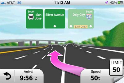
Real-time traffic and fuel price data are also available as separate in-app purchases.
Just last week, Garmin announced that it had completed its acquisition of German GPS firm Navigon, which itself offers a full suite of two dozen GPS applications for iOS covering various countries and regions.
















Top Rated Comments
The only two that I give serious consideration to are TomTom and Navigon. I used to love Navigon when it first came out - they had text-to-speech first, traffic first, etc. TomTom was a sad, pathetic little app that had a hard time even keeping your icon on the road.
A lot has changed since then. TomTom has matched Navigon feature-to-feature and has actually surpassed it with MapShare (submit and download map corrections on the fly). Navigon has a cool visual lane assist feature, but has no voice instructions on what lane to be in like TomTom has.
That's just features. Use the two for a short time and you'll see how much better TomTom's routing is. It takes historical road speed data into account, so the route during rush hour and the route on Sunday morning (even without the traffic add-on) are different. I have found TomTom's routes and ETAs to be dead-on. Navigon's routes are usually pretty good, but the ETAs are way too optimistic. Navigon has a MyRoutes feature where it provides 3 route options for you and lets you pick the one you want. However, since most people use their GPS to find routes to places they've never been, how useful is this?
TomTom's traffic is better, too. Navigon's requires a lot of micro-management, and it reports a lot of information that isn't relevant to your route (e.g., reports incidents hundreds of miles away). TomTom handles everything automatically, and only reports traffic if it actually affects your route, and is worse that the historical data it has (if a road always has slow traffic at rush hour, is it really worth reporting?) The only advantage Navigon has here is that it's traffic is a one-time fee, whereas TomTom's is yearly.
My biggest gripes with Navigon:
1) It doesn't have an "avoid road X" option for re-routing. Maybe I make too big of a deal out of this, but I really don't understand how that's possible. It's basic functionality.
2) The POI search is horrendous. You have to know the exact village that your POI is in or it won't find it. There is a Google search option, but about 75% of the time it returns 0 results even if I know the POI was entered correctly. People will respond to this one and say "use app X to find POIs instead". That's not the point. A GPS app should be able to find POIs. That's basic functionality, again.
TomTom is far and away the better app. Better routing, better traffic, better features, and better performance. However, Navigon got there first and was the better app early on, so they've won the iOS market.
I'm sure the Garmin app is good, but I won't consider any GPS that doesn't store the maps on the phone. I don't care what people say, I don't trust any cell phone provider enough to risk being able to download maps on the fly.
I honestly don't think I will ever buy a stand alone GPS unit ever again. These iPhone GPS apps are getting to be almost as comparable. This latest Garmin app is about 90% comparable to my old Nuvi 860 without the voice recognition and weather.
Anyone try the Garmin on board app on more than on iPhone model? I seem to like the performance on my 3GS better than on my iPhone 4. The text on the 3GS was much easier to read but the 3GS also had a weird problem on its own.
Pressing the home button twice zoomed in on the maps. Pressing it again zoomed in even more. It took several tries to get to the multitasking bar. I'll try it out on another 3GS soon.
The Maps app is NOT a substitute for a true navigation app with the maps installed on the phone.
I know this is off Topic, But Seriously... IMHO GoLive and PageMaker needed killing off as soon as possible. Especially PageMaker!!! It was a god awful application. As for dreamweaver, I still use it on a daily basis and I'm really happy with it. Ive tried many other HTML editors like Coda, Hype and BBE but still end up going back to Dreamweaver... Then again, I still use Quark Xpress, so who am I to comment! :eek:
So bac to topic, Carry on...