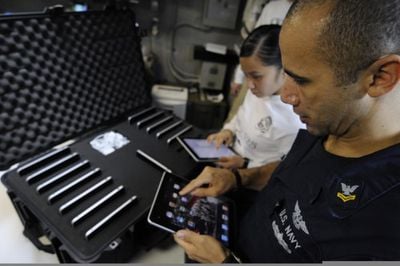
Civilian and military flight crews are increasing looking to the iPad to replace bulky maps and flight manuals, saving weight and ensuring that crews always have the most up to date materials.
In the past month, both American Airlines and Alaska Airlines have begun distributing iPads to their pilots to reduce the number of paper maps flight crews must to carry around and fly with. The switch saves paper, and thus fuel, by reducing the weight of pilots' flight bags which can weigh several dozen pounds.
iPads are also seeing action in war zones. DVIDS reports how Marine Corps aviators are using iPads in Afghanistan:
"iPads allow close-air support aircrew several advantages," said Maj. Marc Blankenbicker, the lead fire control officer for the Marine Aerial Refueler Transport Squadron Harvest Hawk detachment at Camp Dwyer, Afghanistan. "First is the ability to carry 500 large charts, known as gridded reference graphics, on one electronic tablet."
Currently, a handful of 2nd Marine Aircraft Wing (Forward) squadrons use Apple's iPad in Afghanistan. This includes crewmembers for AH-1W and UH-1Y light attack helicopter squadrons, AV-8B Harrier pilots and the crew of the Harvest Hawk equipped KC-130J.
Each of these aircraft provides close-air support for Marines, Afghan forces and other combined team ground troops in Nimroz and Helmand provinces. Marine aviators said the electronic tablet helps them quickly access maps and other data they can use to ensure precision strikes are targeted at enemy positions.
The U.S. Navy is using iPads as well. The image at the top of this article shows U.S. Navy Information Systems Technician 2nd Class Michael Tolbert uploading "geographical data onto tactical Apple iPad tablets to be used for combat operations aboard the aircraft carrier USS Carl Vinson at sea April 19, 2011."
The secure tablet storage box the Navy is using in that picture appears to be a Pelican 1630 Transport Case, available on Amazon.com for $299.94 (with free shipping!).
(U.S. Navy photo by Mass Communication Specialist 3rd Class Christopher K. Hwang/Released)
















Top Rated Comments
Compared to how much it takes to cut the tree, make the paper, print their documents on said paper a number of thousands of times, and destroy them when the new cycles come out? If following the normal AIRAC cycle, those charts get updated every 28 days. Let's use a round figure.. let's say 2000 times, and there are 50 pages per cycle. You're looking at 10000 pages every 28 days. And after that 28 days, they get thrown away.
That, vs. the cost of 2000 iPads, that only need to be bought once. That's a huge SAVINGS over that 28 day period that you're not realizing. That's why AAL and ASA went to iPads over paper charts, and why most Part 121 ops are drifting that way.
BL.
I think the interference issue with airplanes is all BS, a panic inherited from many years ago.
Some flights now allow certain electronic devices to be used, even offer WiFi access.
Plus the whole world is saturated with RF interference. The plane itself generates RF.
The plane's sensors and antennas are external, such as Comm, Navigation, GPS, radio, etc.
In any case, all iOS devices and many others have what is called: "Airplane Mode".
Assuming the iPad wireless connectivity is cut off and these can only use certified apps, I'm guessing they are also SCIF certified. It will be interesting to see these being used in the field. Looks like Navy/Marines with iPads and Army with Android.
My god you're right. Thank god that planes don't use complex computers and electronics just to stay in the air at any given moment, and just about everything else.
I used my iPhone with copilot and a tomtom dock on a long multi-waypoint flight last month and the combination performed flawlessly... that being said, if the app crashed or I lost power to the dock the day would have been very, very sad without backup charts. :(
You still carry paper charts. This isn't much different than flying the charts on the Garmin 1000 glass cockpit. Even though it is highly reliable and convenient, it's still a bad habit to not have your paper charts in your bag and trace out your course with a pencil before your flight.